Difference between revisions of "S22: Testla"
(→Geographical Controller) |
(→Geographical Controller) |
||
| Line 295: | Line 295: | ||
<BR/> | <BR/> | ||
== Geographical Controller == | == Geographical Controller == | ||
| + | The Geological controller is responsible for determining the position of the vehicle as well as the distance and bearing to desired destination. | ||
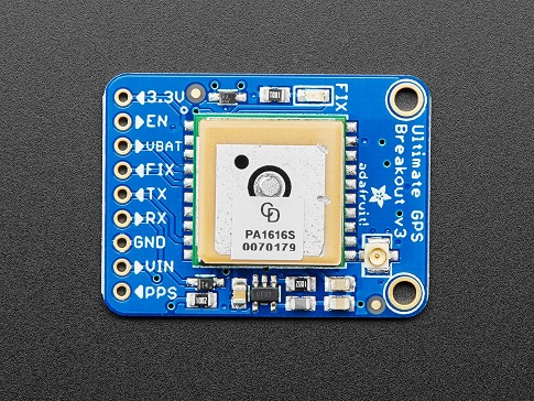
[[File:adafruit_gps.jpg]] | [[File:adafruit_gps.jpg]] | ||
| − | |||
| − | |||
=== Hardware Design === | === Hardware Design === | ||
Revision as of 17:58, 12 April 2022
Contents
Testla
<Group Pic>
Abstract
The Testla project is the culmination of our efforts to create an autonomously operated RC Car by pooling together our experience in software design, hardware design, power systems, and mobile application development. Project development started in February of 2022 and ended in May. (NOTE: One more sentence probably)
Introduction
The project was divided into 5 modules:
- Bridge and Sensor Information
- Motor Operation
- Geological Information
- Driver and LCD Manager
- Android Application
Team Members & Responsibilities
<Provide ECU names and members responsible> <One member may participate in more than one ECU>
- Sensor
- Bang Nguyen --couldn't find your gitlab
- Bang Nguyen --couldn't find your gitlab
- Motor
- Michael Hatzikokolakis https://gitlab.com/mikehatzi8
- Sinan Bayati https://gitlab.com/sinan.bayati
- Geographical
- Scott LoCascio https://gitlab.com/scottlocascio
- Devin Alexander https://gitlab.com/devin_alexander_sjsu
- Communication Bridge Controller & LCD
- Devin Alexander https://gitlab.com/devin_alexander_sjsu
- Link to Gitlab user2
- Android Application
- Thinh Lu https://gitlab.com/lphucthinh40
- Michael Hatzikokolakis https://gitlab.com/mikehatzi8
- Testing Team
- Link to Gitlab user1
- Link to Gitlab user2
(not sure exactly which role Bang is doing...)
Schedule
| Week# | Start Date | End Date | Task | Status |
|---|---|---|---|---|
| 1 | 02/15/2022 | 02/21/2022 |
|
Completed |
| 2 | 02/22/2022 | 02/28/2022 |
|
Completed |
| 3 | 03/01/2022 | 03/07/2022 |
|
Completed |
| 4 | 03/08/2022 | 03/14/2022 |
|
Completed |
| 5 | 03/15/2022 | 03/21/2022 |
|
Completed |
| 6 | 03/22/2022 | 03/28/2022 |
|
Incomplete |
| 7 | 03/29/2022 | 04/04/2022 |
|
Incomplete |
| 8 | 04/05/2022 | 04/11/2022 |
|
Incomplete |
| 9 | 04/12/2022 | 04/18/2022 |
|
Incomplete |
| 10 | 04/19/2022 | 04/25/2022 |
|
Incomplete |
| 11 | 04/26/2022 | 05/02/2022 |
|
Incomplete |
| 12 | 05/03/2022 | 05/09/2022 |
|
Incomplete |
| 13 | 05/10/2022 | 05/16/2022 |
|
Incomplete |
| 14 | 05/17/2022 | 05/25/2022 |
|
Incomplete |
Parts List & Cost
| Item# | Part Desciption | Vendor | Qty | Cost |
|---|---|---|---|---|
| 1 | Unassembled RC Car | Traxxas [1] | 1 | $279.99 |
| 2 | CAN Transceivers | Amazon [2] | 1 | $8.99 |
| 2 | CAN Transceivers | Amazon [3] | 1 | $8.99 |
| 2 | CAN Transceivers | Amazon [4] | 1 | $8.99 |
| 2 | CAN Transceivers | Amazon [5] | 1 | $8.99 |
| 2 | CAN Transceivers | Amazon [6] | 1 | $8.99 |
Printed Circuit Board
<Picture and information, including links to your PCB>
CAN Communication
<Talk about your message IDs or communication strategy, such as periodic transmission, MIA management etc.>
Hardware Design
<Show your CAN bus hardware design>
DBC File
<Gitlab link to your DBC file> [7] <You can optionally use an inline image>
Sensor ECU
<Picture and link to Gitlab>
Hardware Design
Software Design
<List the code modules that are being called periodically.>
Technical Challenges
< List of problems and their detailed resolutions>
Motor ECU
<Picture and link to Gitlab>
Hardware Design
Software Design
<List the code modules that are being called periodically.>
Technical Challenges
< List of problems and their detailed resolutions>
Geographical Controller
The Geological controller is responsible for determining the position of the vehicle as well as the distance and bearing to desired destination.
Hardware Design
An Adafruit Ultimate GPS breakout module using the MTK3339 chipset is interfaced over UART to the Geological controller to provide latitude and longitude updates.
TODO: interface and explain compass
Software Design
On startup the GPS module is initialized to provide updates at 10Hz with a 115200 baud rate. Additionally, the Bridge and Sensor controller sends a desired latitude and longitude to the Geo controller over the CAN bus.
The desired and current position are used to calculate a distance and bearing using the haversine formula shown below.
Moveable Type Scripts: Calculate distance, bearing and more between Latitude/Longitude points
Technical Challenges
< List of problems and their detailed resolutions>
Communication Bridge Controller & LCD
<Picture and link to Gitlab>
Hardware Design
Software Design
<List the code modules that are being called periodically.>
Technical Challenges
< List of problems and their detailed resolutions>
Master Module
<Picture and link to Gitlab>
Hardware Design
Software Design
<List the code modules that are being called periodically.>
Technical Challenges
< List of problems and their detailed resolutions>
Mobile Application
<Picture and link to Gitlab>
Hardware Design
Software Design
<List the code modules that are being called periodically.>
Technical Challenges
< List of problems and their detailed resolutions>
Conclusion
<Organized summary of the project>
<What did you learn?>
Project Video
Project Source Code
Advise for Future Students
<Bullet points and discussion>

